“All of this is a mere preview”
The el Nino climate chaos monster is out of control

The El Niño monster is out of control with temperature anomalies 5.4°F above previous records

As of Sept 23, the world’s oceans have recorded 100 consecutive days of unprecedented heat.

As Autumn begins in the Northern Hemisphere, the El Niño leviathan getting warmed up in the Pacific has already broken every temperature record for previous El Niño events. This cyclical weather phenomenon has far exceeded the highest temperature ever recorded in the Pacific Ocean, several months before it was expected to peak. As of Sept. 10, the world’s oceans recorded 100 consecutive days of unprecedented heat. Although El Niño is not technically a cause of climate change, no credible climate scientist questions whether the collossal  strength of this year’s anomaly is driven by global heating.

NOAA Mid-September data indicates a 5.4° F (3.05C) increase, breaking the previous high set in 2015.

The most recent forecasts predict a peak of 7.2° F for year’s end, a level that is almost incomprehensible in the context of historical data. It’s a factor of 3X greater than the scientific threshold of a “super El Niño.”

When added to the accelerating pace of global warming and the historically elevated temperatures of the ocean, the prospects of 2027 clocking in as the hottest year of all time are a lock in. And with the climate emergency already supercharging violent weather events this year, the impacts on the planet are already apparent. 

Only the beginning

Consensus is that we are actually at the beginning of the most devastating phase of this event. Although the Pacific has already warmed extraordinarily rapidly, NOAA expects El Niño to strengthen further through the autumn and winter. The agency projects a 90% probability of a very strong event during the Northern Hemisphere fall/winter.

That means the classic El Niño consequences should be expected and prepared for beginning now:

  • heavy rain and flooding along parts of the Americas,
  • drought across Australia and Southeast Asia,
  • altered monsoons,
  • extreme heat,
  • Pacific tropical cyclones,
  • challenges to fisheries,
  • disruptions to agriculture

Current impact

In late September 2026, the emerging super El Niño is already producing measurable extreme-weather and ecological effects.  El Niño is now strong enough to influence weather patterns, but not every extreme event occurring in 2026 can be attributed to it.

Summer 2026 events

Severe drought and water shortages in Southeast Asia 

Indonesia and other parts of Southeast Asia are experiencing declining rainfall and water levels. Indonesia has also experienced significant wildfires. The Mekong system is seeing unusually low water levels, affecting agriculture, fisheries and communities dependent on the river.

Wildfires

The combination of heat and reduced rainfall has increased fire danger, particularly in Indonesia/Sumatra.  There are also substantial drought/fire effects in the Caribbean, where Puerto Rico and neighboring areas experienced unusually dry conditions, low stream flows, grass fires and water-supply problems.

Major impacts on Peru’s fisheries

One of the clearest early effects is occurring off Peru, where unusually warm Pacific waters have disrupted the marine ecosystem. Anchovies have moved into deeper, cooler water, and Peru ended its anchovy fishing season early in August. This is economically significant because anchovies are a major source of fishmeal and fertilizer.

Exceptional heat

The developing El Niño is adding heat to an already warming climate. The contiguous United States experienced its warmest June–August on record in 2026, with widespread drought and extreme heat. 

This distinction is important: global warming provides the elevated baseline temperature, while El Niño is now superimposing another source of warming and shifting atmospheric circulation.

5. More powerful and numerous Pacific Cyclones

At the same time, the Pacific is experiencing much more favorable conditions for tropical cyclones. Hurricane Polo reached Category 5 strength off Mexico on September 22, illustrating the contrasting Pacific/Atlantic pattern associated with El Niño.

Flooding and extreme rainfall in parts of the Americas

El Niño shifts the position of the Pacific jet stream and tropical convection, producing drier conditions in some regions and much wetter conditions in others. PAHO reports that drought, flooding, wildfires and food insecurity are already occurring in several countries in the Americas. 

The super El Niño has already shown up in Southeast Asian drought and fires, Caribbean water shortages and fires, disrupted Peruvian fisheries, Pacific tropical-cyclone activity, and an unusually suppressed Atlantic hurricane season. But the event is still intensifying, so the largest global effects are likely to develop during the coming fall and winter of 2026–2.
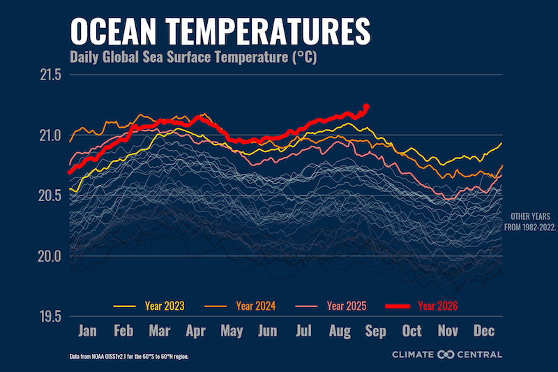
Graph of daily sea surface temperatures

Global warming provides the current elevated baseline temperature, while El Niño is now superimposing another source of warming and shifting atmospheric circulation.
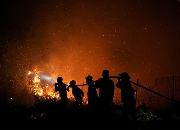
 

El Nino drives indonesian wildfire
Hot and dry conditions in Indonesia have already spurred record wildfires and fatal levels of air pollution, while India has seen vital monsoon rains curtailed. Drought conditions in Central America and the Caribbean are causing crop losses and a slowdown of trade due to low water levels in the Panama canal. The World Food Programme said in August the impacts of El Niño were likely to push about 50 million people into acute hunger and drive prices up.

Global sea-level rise is driven by three major processes.

Unchecks extraction of groundwater for irrigation and industrial use turns out to be an important missing factor in past estimates of sea-level changes. It isn’t good news for the future.

#1 Melting of glaciers and ice sheets ~ 66%

Ice currently on land adds new water to the ocean when it melts or flows into it.

Two major components:

Greenland and Antarctic ice sheets

  • Greenland loses ice through surface melting and increased glacier discharge into the ocean.
  • In Antarctica, warmer seawater melts floating ice shelves from below. This is negating their restraining effect on glaciers, allowing more land-based ice to flow into the ocean.

Mountain glaciers

  • Glaciers are shrinking on virtually every continent.
  • Meltwater eventually reaches the ocean.
  • Collectively, glaciers make a significant contribution to sea-level rise.

Together, land-ice loss accounts for about two-thirds of global sea-level rise.

Important distinction: Melting floating sea ice in the Arctic and Antarctic makes only a small contribution to sea levels rise because it is already floating in the ocean. It is melting land ice that substantially raises sea level.

Global ice sources

Sea Level 101, Part Two: All Sea Level is "Local" - NASA Science

#2 Thermal expansion ~ 33%

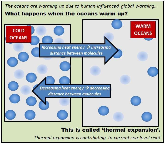
As the ocean absorbs heat from global warming, seawater expands. This is called thermal expansion.

  • Water molecules move farther apart as their temperature rises.
  • The amount of water doesn’t increase, but its volume does, pushing the ocean surface upward.
  • The ocean absorbs more than 90% of the excess heat accumulating in Earth’s climate system.
  • Thermal expansion currently accounts for roughly one-third of global sea-level rise.

This process is particularly important because warming penetrates progressively deeper into the ocean.

.

#3 Human extraction diverts more water into the oceans ~ 1%

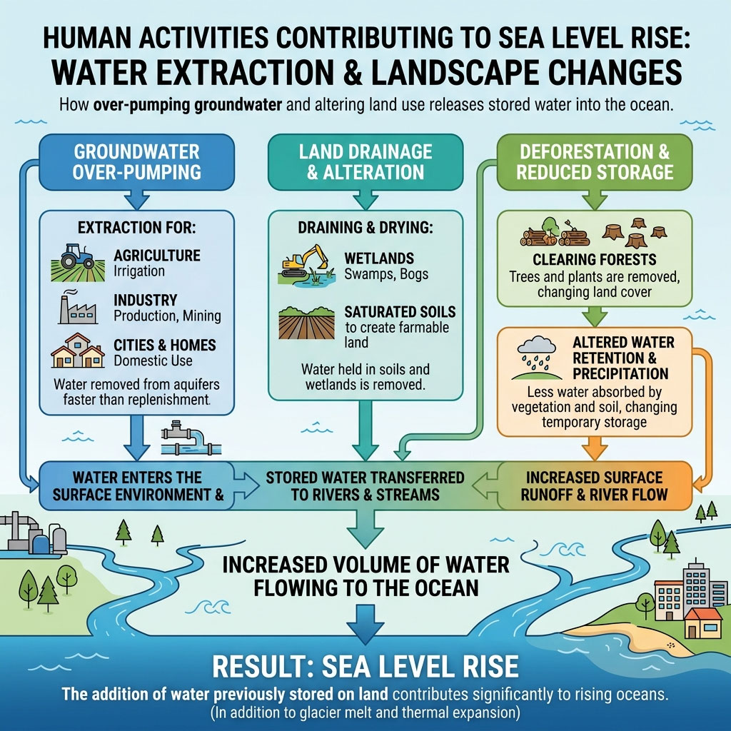
The third process is less obvious: water is transferred between the land and the ocean. Extraction of groundwater for irrigation and home and industrial use is an important missing piece of the puzzle. Until now, it has not been included in estimates for past and current sea-level changes and for projections of future rises
  • Groundwater pumping: water extracted from aquifers for agriculture, cities and industry can eventually reach the ocean.
  • Drainage of wetlands and soils: stored water can be transferred to rivers and ultimately the ocean.
  • Deforestation and changes in precipitation: alter how much water is temporarily stored on land.
This third component is relatively small compared with thermal expansion and land-ice loss, but it matters when scientists construct the complete global sea-level budget.

Human extraction diverts more water into the ocean

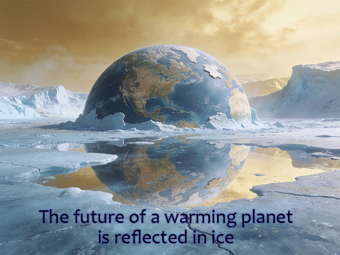
Future of a warming planet is reflected in ICE

The words of the prophets are written in ice.

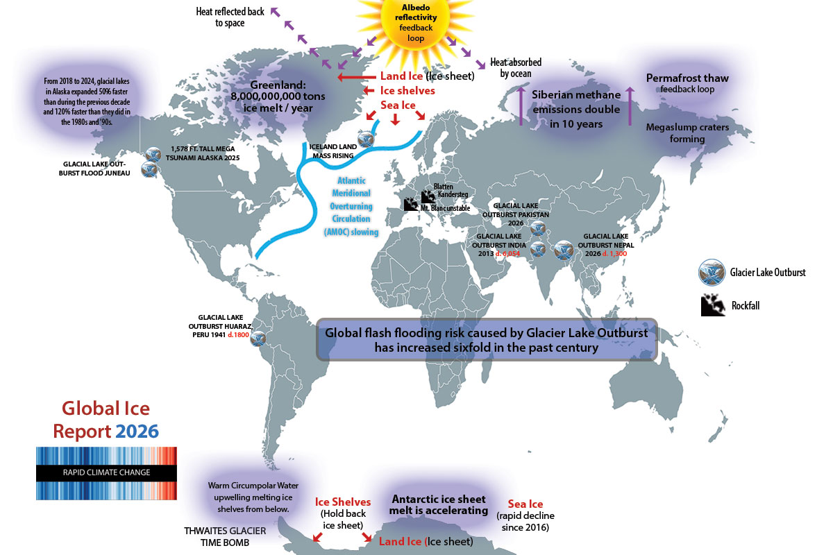
The interaction between global ice stores and climate is a critical factor in understanding what’s happening and what’s going to happen. 

Detailed summary here


Glacial Lake Outbursts | Collapsing Permafrost | Feedback loops

Crumbling mountains | Atlantic Meridional Overturning Current

The future of a warming planet is reflected in ice

The key role of ice in global warming


The cause and effect relationship between runaway global warming and Earth’s vast stores of frozen water is far more significant than melting ice caps and shrinking polar bear habitat. From Greenland’s ice sheets to Siberian permafrost thaw to collapsing Alpine mountain slopes, there is virtually nowhere on the Earth the planet’s vast reserves of ice aren’t melting fast. For better or worse, the consequences of this phenomenon are not obvious on a global scale. This page covers several interrelated topics that don’t penetrate public awareness.

Future of a warming planet is reflected in ICE

Polar Ice Formations: How they affect global climate


Fundamentals: Location, location, location

A key factor in global ice melting patterns is an often overlooked matter of basic geography.

  • The North Pole is frozen ocean (Sea Ice)
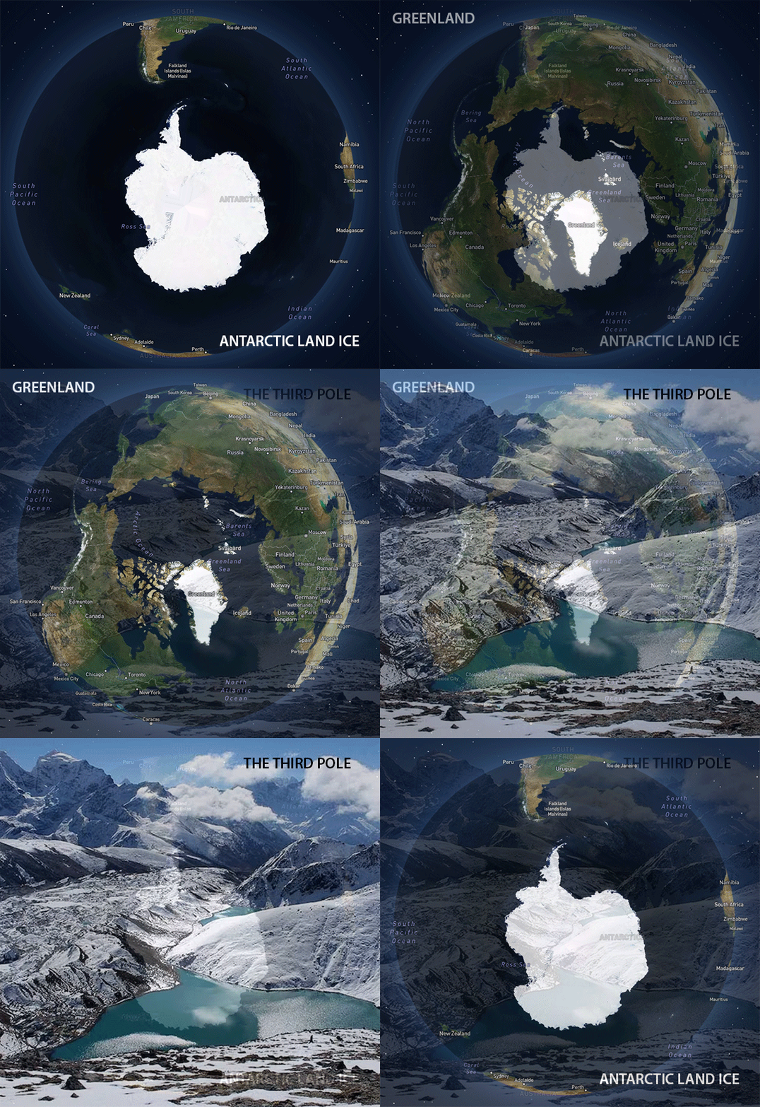
  • The South Pole is a massive land continent covered by trillions of tons of snow pack and ice (land ice, sea ice, shelf ice).

For the purposes of climate science, the three categories of ice are dictated by where ice is located and what state of matter it is in.

SEA ICE : Disappearing rapidly in the Arctic and more sporadically in the Antarctic since 2016. Sea ice floats but does not raise sea levels significantly when it melts. It does affect weather patterns and the Albedo reflectivity feedback. Extreme Antarctic sea ice variations have contributed to ocean current destabilization, which in turn destablizes weather patterns.

LAND ICE (fresh water): Trillions of tons of land ice on Greenland, Alaska, Iceland and the Antarctic continent contain enough fresh water to raise sea levels several meters.. 

SHELF ICE (fresh water): Hybrid formations are critical to braking the flow of land ice into the ocean. The “front” of an ice shelf rests on land and the “back” floats in the ocean, subjecting it to accelerated warming. (See middle column)

The Doomsday Ice Shelf

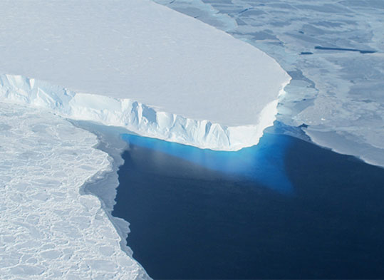
Thwaites Ice Shelf

The Twaites Glacier ice shelf on the West Antarctic peninsula is known as the “Doomsday Glacier.”  It is expected to break up in the very near future. If it collapsed completely, it would raise global sea levels about two feet. Equally alarming, the Thwaites and other coastal shelves act as a brake on the advancing land ice on the continent behind them.

Albedo Reflectivity Feedback

Albedo reflectivity Feedback Number One

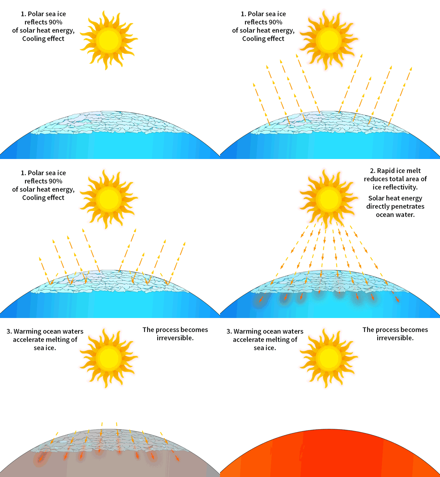
ALBEDO REFLECTIVITY FEEDBACK LOOP: The mechanism of this relentless positive feedback cycle is easy to understand. When sunlight radiates on Ice and snow, the heat energy is reflected back into space. But when sea ice disappears, the heat energy is absorbed directly into dark ocean water, heating it. The warm ocean melts more ice, which then opens more water to the heat energy. Repeat. See other climate feedbacks..

“Third pole” ice melt threatens water supplies for 2 billion humans

The Hindu Kush Himalaya region supplies water to major river systems including the Indus, Ganges, Brahmaputra, Yangtze, Yellow River, Mekong and Amu Darya


The Himalayan ecosphere is changing before our eyes

DISAPPEARING ICE IN HIMALAYAN GLACIERS IS ACCELERATING A MAMMOTH WATER CRISIS

The Himalayas store more frozen water than any other source except the Arctic and Antarctic ice sheets. While glaciers are visually compelling as tourist attractions, they are also essential as renewable water sources for agriculture and drinking water. These high mountain glaciers feed rivers that sustain nearly one-fourth of the world’s population. For thousands of years, billions of humans downstream have relied on a predictable seasonal release of glacial water into rivers, but global warming has quickly changed the scenario.  With some glaciers losing ice mass at four times the normal rate, the region faces a convergence of environmental, health, and geopolitical crises.

TWO-EDGED SWORD: Near term, accelerated melting produces too much water too quickly—including devastating Glacial Lake Outburst Floods (GLOFs – see right column). Longer term, continued glacier shrinkage means less dependable water during the dry season, when millions of people most need it. At some point, when the glaciers are gone, the outcome is the permanent end of this water source.

.

Glacial Lake Outburst Floods

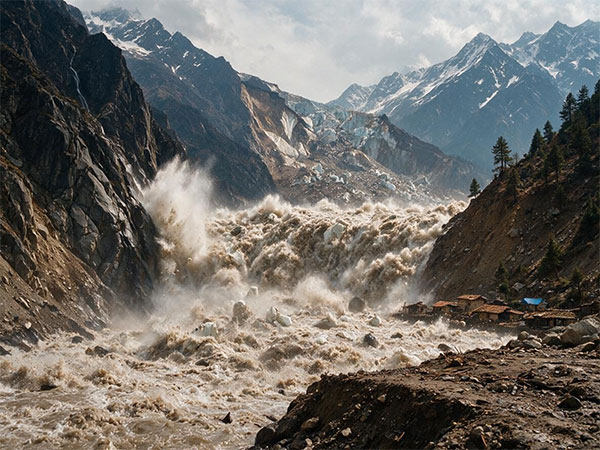
160 ft wall of water sweeps down Himalayan pass

While the catastrophic Nepal event that killed 15,00  in
August 2026 is a major GLOF event, it is far from an isolated occurrence. In 2023, the South Lhonak GLOF in Sikkim, India, killed dozens of people and caused extensive infrastructure damage.

HOW GLOFs HAPPEN: As glaciers retreat, meltwater accumulates in lakes behind unstable moraine or ice dams. These lakes can grow rapidly. A landslide, avalanche, ice collapse, earthquake or extreme rainfall can suddenly displace water or breach the dam:

These floods travel rapidly down narrow valleys, carrying boulders, mud, trees and enormous quantities of sediment.

About  200 glacial lakes across the Hindu Kush Himalaya are considered dangerous.  A significant acceleration in GLOF events began in the 1980s, with the annual frequency increasing from 5.2 GLOFs during 1981–1990 to 15.2 GLOFs during 2011–2020. Overall, the long-term trajectory of reported GLOF frequency parallels variations in global air temperature, with a lag of about 20 years. GLOF risk will increase substantially as warming continues

Destabilized mountain structure

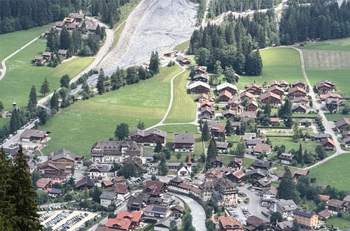
Thawing mountain threatens Swiss village

DESTABILIZATION: ROCK FALLS The Himalayan climate threat is more complex than melting glaciers alone. In a separate process. thawing alpine permafrost is causing a destabilization of the entire high-mountain environment.

For thousands of years, rock formations have been held together by ice to create a permafrost, which functions more or less as a “glue” to hold rock and soil in place. When ice that has previously remained frozen year round begins to melt and refreeze, water penetrates cracks previously stablized by frozen soil. As this cycle repeats, the entire mountain slope is structurally compromised. At some point, the side of the mountain fails, in the form of a rock fall or landslide. Rockslides often trigger GLOFs as debris cascades into glacial valleys. 

Glacier retreat also removes the ice that can buttress mountain slopes. 

“At some point, when the glaciers are gone, the outcome is the permanent end of this water source.”

Global consequences of rapid Permafrost thaw

A relentless methane feedback loop and transformed terrain


Driven by Arctic warming four times faster than the rest of the planet, the vast tundra plains of the north are thawing rapidly. While relatively few people think much about these unseen forces, the ramifications are global and implacable.

Methane Plumes: Melting permafrost is causing release of CO2 and CH4 trapped beneath once frozen surface. This is one cause for the rapid uptick in global atmospheric methane. Siberian levels of CH4 emissions have doubled in ten years.

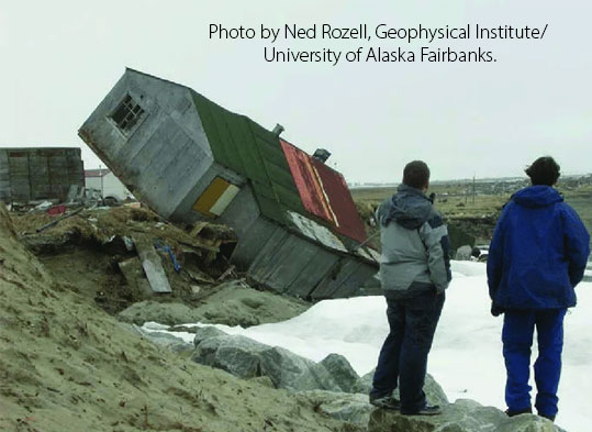
Infrastructure Collapse: Biblical savior Joshua ben Joseph recommended not building your house on sand, but he should have also cautioned us not to build on permafrost. In Alaska, Siberia and northern Canada, buildings, highways and pipelines are falling down and smashing into the sea. Humans constructed these artifacts under the assumption that the land would stay solid, but it is NOT staying solid. As the ground sinks, humanity’s limitations are exposed. The situation is worse in coastal communities as increased water temperatures reduce protective ice and allow waves to wreck permafrost bluffs and increase erosion. 

Read a current story on collapsing buildings in Alaska..

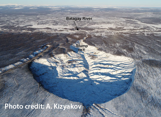
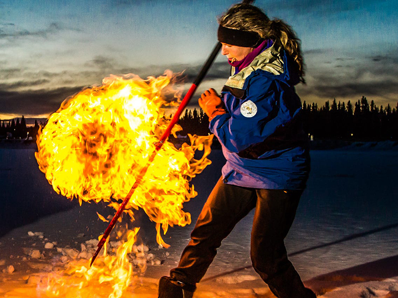
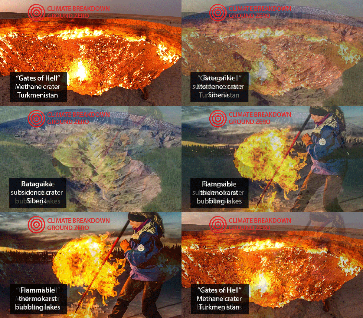
Megaslump Craters: These massive blowholes are blasting out all over the far north, transforming Arctic terrain into a spooky landscape called Thermokarst. These unsettling and often very large craters (also known as thaw slumps) are formed as once-trapped methane escapes the permafrost that once trapped it below. Megaslumps and the starkly strange thermokarst terrrain that accompanies them are not new, but they are multiplying as the tundra transforms. Sometimes a megaslump starts with a small soil collapse, other times there is a dramatic blowout when pressure grows too great. Arctic scientists now videotape footage of grassland wobbling as the substrata becomes less solid. Multiple researchers have entertained themselves by setting escaping methane gas afire as it is released from long-frozen ponds..

Megaslump craters blasting out in Siberia/
The Batagaika crater is a thermokarst depression in the Chersky Range of Suberia. Known locally as The Gates to Hell, it is currently the largest known permafrost crater in the world. It continues to growing

Microbes beneath the tundra: Pathogens have already been released: 

Permanently frozen environments are natural reservoirs for microorganisms, including viruses, bacteria and humans pathogens. It is not currently considered likely that dangerous microbes such as smallpox are about to be released, but there is no question that dormant viruses will be released as the Arctic continues to heat up. The region is warming four times as fast as the rest of the planet. Which is warming very fast.

In 2015, researchers from Aix-Marseille University isolated two large DNA viruses in Siberia frozen for 30,000 years in ancient permafrost. They were not a threat to humans.

There was a well-documented anthrax outbreak in 2016 in Siberia. It killed thousands of reindeer. The cause of the outbreak is attributed to the activation of spores due to a permafrost thaw, accelerated during the summer heat wave of that year.

Permafrost is thawing rapidly in the Arctic, releasing once trapped methane and carbon monoxide.

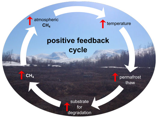
Powerful Methane Feedback Loop as Arctic tundra thaws

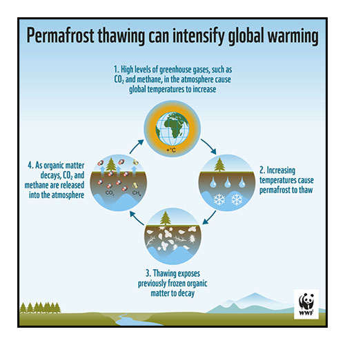
  1. Permafrost thaws, releasing greenhouse gases (CO2 , CH4).
  2. GHG’s trap heat in the atmosphere, increasing surface temperatures
  3. Permafrost melts faster, releasing more CH4.

Melting permafrost and damage to human infrastructure

Collapsing Arctic infrastructure as permafrost destabilizes: Nature has a way of pointing out the hubris of human endeavor.

Methane released from permafrost thaw

As once frozen Arctic ponds melt, flammable methane lurks beneath the surface.

“While relatively few people think much about these unseen forces, the ramifications are global and implacable..”

Greenland and Iceland: Unexpected forces at work

Rising land masses and changing global ocean currents


As massive quantities of fresh water enter the North Atlantic, things are changing quickly

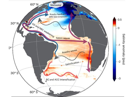
1. THE ADDITION OF MASSIVE AMOUNTS OF FRESH WATER INTO THE NORTH ATLANTIC IS SLOWING DOWN THE GULF STREAM (AMOC)

The Gulf Stream is the best known component of the global ocean current known as the Atlantic Meridional Overturning Circulation (AMOC). This global current is responsible for a major determining factor for planetary weather. It moderates Northern Europe’s climate, preventing a climate more like Siberia’s (see middle column for more). 

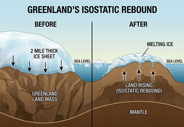
2. THE LAND MASS OF BOTH ISLANDS IS RISING AS THEY SHED THE WEIGHT OF ICE CAPS

There is no question that the addition of two mile thick melting ice caps into the ocean is raising sea levels. There is a range of projections regarding how quickly this process is taking place, but there is no doubt that it is gaining speed. Sea level rise is about double what it was in 1993. 

But there is a less obvious effect as well. As the ice sheets melt and flow into the North Atlantic, the land beneath is lifting up. This paradoxical scenario, in that these two land masses will experience less net sea level rise that other coastal areas. 

.

Slowing the Atlantic Current

Freshwater melting from Greenland and Iceland affects the AMOC

Melting of the Greenland Ice Sheet weakens the Atlantic Meridional Overturning Circulation (AMOC) by shedding colossal quantities of fresh water to the North Atlantic. The system is currently the weakest it’s been in more than 1,000 years, having lost 10% to 20% of its strength due to climate change.

The AMOC is essentially a huge ocean conveyor that distributes heat from Tropical regions to the north. When the current slows, it transports less heat to Northern Europe. Even as the specific magnitude of the changes are the topic of ongoing research, the basics of the mechanism are straightforward and measurable. Most research indicates that the AMOC is already slowing.

HOW IT WORKS: Warm, salty surface water moves northward through the Atlantic. In the subpolar North Atlantic and Nordic Seas, some of this water cools, becomes denser and sinks. The cooler water then flows back southward. This sinking action is the primary engine driving the overturning circulation.
Freshwater stored on land. When Greenland’s ice sheet melts and water reaches the North Atlantic, it changes the salinity of the ocean. The Greenland ice sheet contains enough freshwater to raise global sea levels by about 25 feet (7.4 meters) if it were to melt completely. It is the second-largest body of ice on Earth, and it is currently losing mass at an accelerating rate due to surface melting and the calving of glaciers into the sea. Credible estimates of melt rate are 12 million gallons a second or 266 billion tons a year. See article on sea level rise.

Arctic islands land mass lifting 

Greenland land mass rebounds as fresh water ice melts

As the miles-thick ice caps that cover Greenland and Iceland  melt and pour into the ocean,  the land beneath is rebounding as the burden eases. The seas around them may actually appear to be lower when compared to the global inundations that are happening around the rest of the planet. Even as these two islands are contribute significantly to global sea level rise – about 20% –  this paradox will mean expanding coastlines, dried-up fjords, and unforeseen challenges. 

THE NEPAL GLACIERS WILL FLOOD AGAIN. AND SO WILL HUNDREDS OF OTHERS.

This Himalayan mega catastrophe is one extreme incident in a global warming trend that also includes permafrost thaw (and its stunning consequences) in the Arctic, Glacier Lake Outburst Floods (GLOF) across all Alpine regions and the literal destabilization of entire Swiss mountainsides, leading to rock slides that take out entire villages in first world nations.

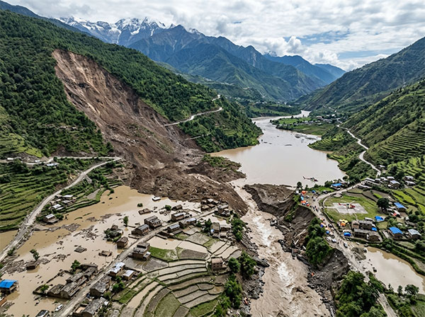
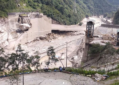
Hundreds are dead and thousands are missing in Nepal killer landslide

A 160 Ft high wall of mud, water and debris crashing down the valley at 45 MPH. Think about that.

DEATH TOLL: 1,280 | MISSING: 5,620

The staggering scale of the deadly collapse of Himalayan mountain glacier and rock is getting plenty of media attention, primarily because of the dramatic destruction-and-death visuals that draw humans to their screens. Unfortunately, the epic scope of planetary heating’s role in these events is underplayed in most reporting as corporate media remains timid about realistically engaging with an uncomfortable topic. The connection with related trends and events in other parts of the world is largely missing.

This mega disaster was caused by global warming

Strictly speaking, this specific glacial flood can’t be directly attributed to global warming in terms of formal cause and effect. The immediate trigger was the collapse of glacier, rock and ice on the north slope of Langtang Lirung, which generated a huge debris flow followed by catastrophic flooding downstream. Nevertheless, there is virtually no question that planetary heating and its amplified effect at higher altitudes made the overall mountain environment unstable. This is a particularly alarming iteration of a complex global phenomenon. It’s all about the ice (see below). 

The key take-away is: this is not an isolated incident. It is not a one time event. Similar scenarios have increasing in frequency in mountainous regions everywhere. Each year brings more GLOFs, rock slides and collapses with magnified catastrophic results. 

The Nepal disaster was a cascade of climate-sensitive occurrences:

1. Global warming is shrinking and destabilizing Himalayan glaciers.
The Himalayas are warming rapidly. Glaciers have been losing mass, exposing rock and altering the stresses acting on mountain slopes. The Langtang region has experienced particularly substantial glacier loss, also called glacial retreat.

160 ft wall of water sweeps down Himalayan pass

The floods that devastated a hundred mile long area in Nepal were the end result of a chain reaction that originated high in the Himalayas.  A massive landslide in an upstream mountain pass wiped out a large chunk of land and glacial ice. The event caused the energy equivalent of a 5.2 earthquake, registered on seismographs around the globe. Thousands of people will die.

2. Permafrost is thawing.
At high elevations, ice within fractured rock acts like cement. When temperatures rise, that ice melts and water penetrates the cracks. The result is a progressive weakening of cliffs and mountainsides. Scientists investigating the August 26 collapse specifically point to melting permafrost and glacier retreat as contributors.

3. Weakened slopes suddenly fail.
At Langtang Lirung, a huge section of rock and ice apparently collapsed. The material crashed into the valley and river system, creating an enormous debris flow.

4. The debris flow transformed into a catastrophic flood.
The avalanche of rock and ice temporarily obstructed waterways and sent enormous quantities of water, mud and boulders downstream. River levels reportedly rose by as much as 30 feet in about 30 minutes.

..

THIS IS NOT AN ISOLATED INCIDENT

Rapid warming is changing the historically frozen ground and glaciers that helped stabilize Alpine slopes.

A major 2026 scientific study of 8,607 climate-related landslides in the eastern Himalayas found a striking pattern: the annual volume of landslides at elevations above 10,000 feet increased fivefold over the previous three decades. Incidents of landslides and rock falls have been migrating upward as glaciers retreat and permafrost melts.

Another study modeling landslide processes in the northern Himalayas estimated that, during 1991–2019, landslides were driven by a combination of rainfall (~38%), permafrost thaw (~33%), and glacier/snow melt (~29%). The researchers project that future warming will increase landslide triggering, through increased rainfall and permafrost thaw.

The ice goeth, Man: The mostly unknown consequences of global ice collapse

Siberia Emissions doubled in 10 Years

Arctic perma (?) frost thaw

THE GLOBAL EFFECTS OF PERMAFROST THAW IN ARCTIC REGIONS are numerous and underreported. The region is warming twice as fast as the rest of the planet.

1. Methane release from beneath the once frozen tundra of Arctic regions has doubled in the past ten years. The powerful greenhouse gas had been trapped; now it isn’t. This phenomenon is driving one of the most powerful and probably irreversible climate feedbacks.

2. Collapsing infrastructure: The very ground beneath our mukluks has become unstable as buildings, roads and other infrastructure built on once solid ground fails. In places, grasslands are becoming wobbly as the substrate melts. 

3. Megaslump craters blasting out all over. These wacky formations (also known as thaw slumps) are not new, but suddenly they are growing and multiplying in Siberia. Megaslumps include land formations such as the ever-expanding Hell’s Gate crater in Siberia and thermotarga landscapes.

4. What lurks below? Permanently frozen environments are natural reservoirs for microorganisms, including viruses, bacteria and humans pathogens. It is not currently considered likely that dangerous microbes such as smallpox are about to be released into the world, but there is no question that dormant viruses will be emerged as the Arctic continues to heat up. There was indeed an anthrax outbreak in Siberia in 2016.  The trigger of the outbreak was ascribed to the activation of spores as permafrost thaw was accelerated during the summer heat wave of that year.

Thawing mountain threatens Swiss village

Increased rock slides on destabilized mountainsides as ice “glue” melts.

The exceptionally hot summer of 2026 in the Alps has been marked by a record number of rockfalls, – some of them fatal – with a large majority attributable to the climate crisis.  The cause is the rapid thaw of the ice or glue embedded in the rock face of mountains, which has held the slopes secure for millennnia. This year is on pace to smash existing records, both frequency of rockfalls and the sheer volume of rock breaking away from the mountains on an almost daily basis. The total is expected to hit 450 events. A few decades ago, the expected number was a few dozen. Link here for more.

Glacial Lake Outburst Floods increase globally, threatening civilization downstream 

Following the initial disaster, two more glacial lakes formed in Nepal, near the source of the ice-rock avalanche that triggered flooding 

GLOFs are not new, but their incidence in ticking up as Alpine regions destabilize. This includes regions from Pakistan to Alaska to Europe.As glaciers retreat. the lakes as their end points expand behind moraine barricades or dams. When they fail, they release hundreds of billions of gallons of water, carrying rock and debris as they cascade down valleys and passes. Virtually every glacier on the planet is melting, most very rapidly. For example, glacial lake flood outbursts have become an annual event near Juneau Alaska.

Fungal diseases moving north as the West heats up and dries out

Valley Fever (Coccidioides) is one of dozens of diseases expanding range globally.

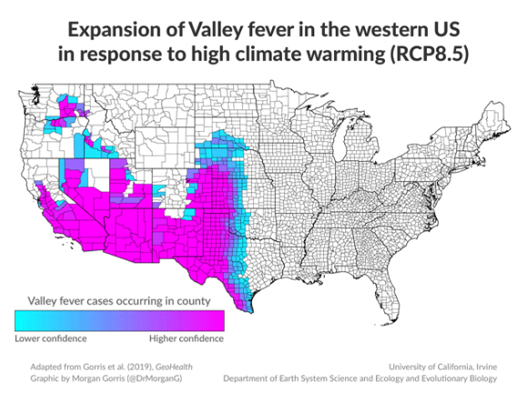
Climate change is the primary driver of the increasing risk of Valley Fever in the western United States. The effect is two fold, raising both the probability of infection in existing ranges and expanding the reach of the affliction northwards.

Historically, most U.S. Valley fever has occurred in Arizona and California, with cases also occurring in Nevada, New Mexico and parts of other western states. But as the historic drought progresses, Coccidioides spores have been documented considerably farther north, including Washington State. Climate modeling suggests that continued warming could make portions of states such as Idaho, Wyoming, Montana, Nebraska, North Dakota and South Dakota increasingly suitable for the fungus.

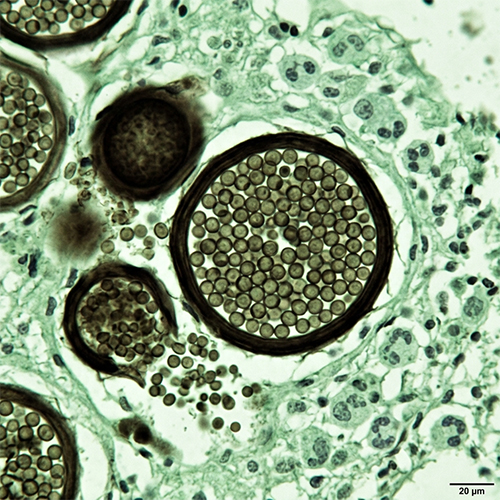
Fungal spores cause Valley Fever

WHAT IS IT?

Coccidioides is an airborne soil  fungus, found in the form of spores spread by the wind. Valley Fever is caused by inhaling the spores, which thrive in hot, relatively dry environments.

The primary way to contract Valley Fever is to inhale in the microscopic fungus which can be lifted into the air after infected soil is disturbed by things like high winds, construction, recreational activities and agriculture. The fungus gets deep in the lungs and mutates, which leads to a flu-like disease. Valley Fever doesn’t usually kill you, but it does make your wish you were dead.  About 1% of cases are fatal, with 10% of patients developing long term lung damage.

Global warming is expanding the range of Valley Fever as the American West becomes more and more arid with the rise of global temperatures. 

VALLEY FEVER GLOBAL WARMING DRIVERS

There are several mechanisms at work:

  • Higher temperatures: Warmer conditions are associated with higher Valley fever incidence. 
  • Drought and drying soils: Dry soils become more prone to generating dust, which can carry fungal spores aloft. 
  • Rain | drought cycles: Rain can stimulate fungal growth, while subsequent drying can leave spores in the soil that become airborne. Research suggests substantial increases in risk follow swings from unusually wet conditions to drought.
  • Longer dry seasons: Recent research using California data from 2000–2023 found that hot, dry conditions cause the Valley fever transmission season to begin earlier and end later. When both spring and fall were unusually dry, the estimated transmission season was nearly four weeks longer.
  • Wildfires and dust: Fires disturb soil and vegetation, while drought and extreme heat increase dust. Both can increase airborne exposure to Coccidioides spores.

Valley Fever is spreading

Scientists are warming that the potential for an epidemic is significant.  A 2026 CDC analysis found that Arizona’s reported Valley fever incidence approximately doubled between 2005 and 2022, with most cases concentrated in Maricopa, Pima and Pinal counties. About 95% of U.S. reported cases occur in Arizona and California. But that is likely to change.

California experienced a particularly striking episode in 2023, reporting 9,054 cases—its second-highest annual total on record. Researchers linked the subsequent high risk to the dramatic transition from drought to unusually heavy precipitation and back toward dry conditions.

Valley Fungal Fever

Viruses and pathogens on the move world wide

The warming climate and land-use changes have been having a global effect on such well-known diseases like Dengue, Chikungunya and Yellow Fever. These are high profile maladies spread by mosquitoes, moving rapidly into new regions where there is not likely to be natural resistance. They are far from the only diseases coming your way.

A 2022 study estimates that more than half of known human pathogenic diseases could be aggravated by climate change.

As an example, take a look at Argentine Hemorrhagic Fever (AHF) a once rare but serious disease carried by rodents. Both the United States and Soviet Union researched them as a potential agent for biological weapons. That can’t be good. AHF was once confined mostly to rural areas, but is now moving into cities.

HP Lovecraft mountains of madness

Dengue, a flulike illness that can be fatal, is one of the fastest-growing infectious diseases in parts of South America, their spread also linked to environmental degradation and a warming planet. More than 10 million cases and over 16,000 related deaths have been reported to the World Health Organization since the beginning of 2024..

Scientists have also linked climate change to the spread of the Andes virus, a rare but dangerous hantavirus — another type of rodent-borne pathogen present in South America — that was linked to three deaths on a cruise ship earlier this year. 

ZOMBIE VIRUSES LURKING BENEATH THE (NOT SO) PERMAFROST?

One of the most powerful climate feedbacks is the release of methane once trapped beneath the frozen tundra or permafrost that covers much of the Arctic. But methane is not the only potentially scary thing under there.  Permanently frozen environments are natural reservoirs for microorganisms, including viruses, bacteria and humans pathogens. It is not currently considered likely that dangerous microbes such as smallpox are about to be released, but there is no question that dormant viruses will be released as the Arctic continues to heat up. The region is warming twice as fast as the rest of the planet. Which is warming very fast.

In 2015, researchers from Aix-Marseille University isolated  two large DNA viruses in Siberia frozen for 30,000 years in ancient permafrost. They were not a threat to humans.

There was a well-documented anthrax outbreak in 2016 in Siberia. It killed thousands of reindeer. The cause of the outbreak is attributed to the activation of spores due to a permafrost thaw, accelerated during the summer heat wave of that year.


Siberian methane emissions have doubled in a decade: new UK research

Melting glaciers and thawing permafrost are opening pathways for ancient methane gas to be released—a feedback loop caused by global warming. These methane emissions are now out of human control. Once this release mechanism has been triggered, we can neither stop it nor reverse it.

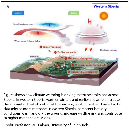
Siberia methane emissions double

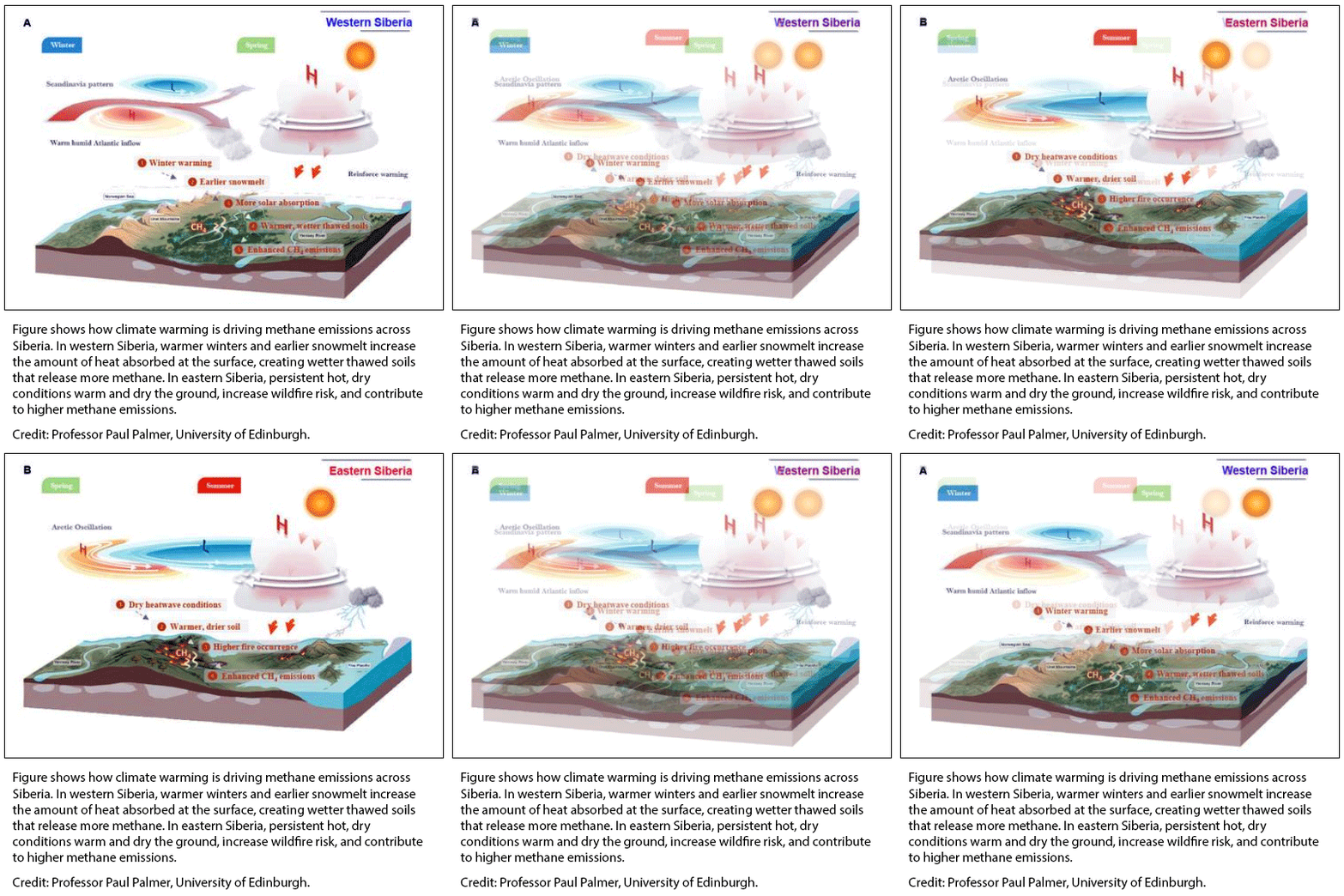
In western Siberia, warmer and wetter conditions are boosting methane production in wetlands

In eastern Siberia, hotter and drier conditions are fueling wildfires, which release methane and further destabilize the tundra ecosphere. 

Methane emissions from Arctic Siberia have more than doubled over the past decade, according to new research co-led by scientists at the University of Edinburgh’s National Centre for Earth Observation (NCEO). The international research team analyzed satellite and atmospheric data spanning 2010 to 2023. They found that methane emissions across Siberia have been rising by around 5% per year, with emissions during the summer growing season now more than twice as high as in 2010.

This alarming report was released August 6 2026. Much of this RCC article is taken from that source.  While the science is complex, the cause is not that complex: permafrost is thawing rapidly, releasing CH4 that had been trapped for millennia.

Link to report

Ignored by almost all corporate media, CH4 is a far more potent greenhouse gas than CO2

The focus on CO2  as the primary greenhouse gas is accurate as far as it goes. But in terms of major threats to the future of the planet, the CH4 molecule represents an additional unknown factor contributing to the speed of warming. While misinformation specialists can make CO2 sound benign or even beneficial, applying that argument to methane is far less credible: Methane blows up, carbon dioxide does not. Methane is a particularly potent greenhouse gas, trapping significantly more heat than carbon dioxide over short time periods and is an emerging major contributor to global warming still flying under the radar. 

Methane arctic effects

methane-levels-increase

It’s not just Siberia: Global methane levels are still surging

Methane has always occurred naturally, but human-caused sources have increased exponentially as civilization exands. One of the surprising origins are wetlands, which are now producing 

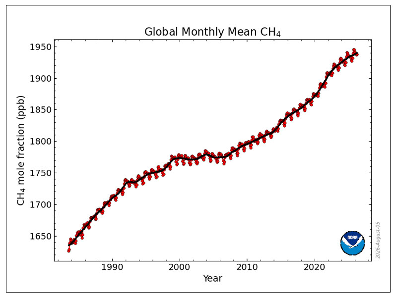
Atmospheric methane reached about 1,936.6 parts per billion (ppb) in 2025, roughly 2.66 times its preindustrial concentration. NOAA researchers report that methane growth averaged about 7.8 ppb/year during 2023–2025, compared with an extraordinary 15.2 ppb/year during 2020–2022.
Methane release concentrations are not presently accelerating as they did around 2020–2022, but they remain at record levels, and the underlying global methane emissions problem remains serious.

“While misinformation specialists can make CO2  sound benign or even beneficial, applying that argument to methane is trickier. Because Methane blows up.”

Methane permafrost feedback loop

A relentless feedback loop: As Arctic permafrost thaw accelerates, more CH4 is released into the atmosphere, which warms the planet further, which melts more permafrost, etc. etc.

Casual followers of climate collapse science are familiar with feedbacks such as albedo and wildfire cycles, but the permafrost collapse sequence is not necessarily obvious until you hear an explanation. Then you can’t unhear it.
Scientists are not yet certain how damaging this cycle could become, but it raises the risk of both long-term and very sudden short term consequences. Over time, the Arctic could shift from storing carbon in frozen ground to releasing increasing amounts into the atmosphere.

Thawing permafrost can release both newly generated methane and ancient methane/carbon already stored in the frozen ground.

Don’t confuse “total accumulation” with “rate of increase.”  

This is how they do it: Atmospheric methane reached a record 1,936.6 parts per billion (ppb) in 2025, roughly 2.66 times its preindustrial concentration. NOAA researchers report that methane growth averaged about 7.8 ppb/year during 2023–2025, compared with a frightening 15.2 ppb/year during 2020–2022.
The quantity of methane spewed into the atmosphere the past few years has declined (temporarily). The misinformation gang characterizes this as good news: as if it has reversed or stopped. We are emitting less, but we’re still emitting. The quantity of accumulated methane continues to rise. It has risen more slowly the past year or so, but there is more CO2 in the atmosphere each year. It is still rising.

The slowing of the rate of increase is likely to be temporary. considering the powerful feedback loop at work here. See the column to the left.

It’s not science fiction if it’s real. How much methane is down there, and what else is lurking?

Scientists estimate permafrost buried beneath the Arctic Ocean holds 60 billion tons of methane and 560 billion tons of organic carbon — making it a major source of greenhouse gases not currently included in climate projections. 

WETLANDS GENERATING MORE CARBON: Most methane emissions come from human activity – including from the fossil fuel industry, landfill sites and agriculture. However, 40% of methane emissions are from natural sources but with a big caveat: Wetlands have become the world’s largest natural source of methane emissions with alarming increases reported in the past few years. The reason is that these ecosystems give off more carbon dioxide and methane as they heat up, accelerating decomposition.
MICROORGANISMS RELEASED Permanently frozen environments are natural reservoirs for microorganisms, including viruses, bacteria and humans pathogens. Most of these theoretically disappeared thousands of years ago, locked in the ice of glaciers and permafrost plains. So far, these are mostly dormant, but there was a well-documented anthrax outbreak in 2016 in Siberia. It killed thousands of reindeer. The cause of the outbreak is attributed to the activation of spores due to a permafrost thaw, accelerated during the summer heat wave of that year. 

HP Lovecraft mountains of madness

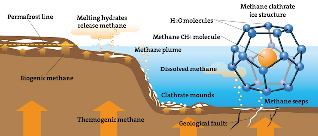
Permafrost contains almost twice as much carbon as the atmosphere, with ~20 Gigatons of permafrost-associated methane trapped in methane clathrates.

Clathrate beneath the Arctic

Potentially game changing Fire Ice (clathrates) factor beneath the sea  

Below the surface of the Arctic seas lurks another potentially ominous peril. Composed of methane frozen within a crystal of water, methane clathrate (CH4·5.75H2O) or “fire ice” is found in the deepest sediments of the ocean. As the seafloor temperature climbs, these reservoirs appear to be destabilizing, releasing methane into the ocean and atmosphere. While this process is not fully understood at this point, evidence is clear that there have been dramatic, rapid climatic consequences in the past. Although unproven, the “methane burp” hypothesis contends that an event during the Paleocene epoch raised deep ocean temperatures about 10°F.
Additional Rapid Climate Change Articles

Previous stories on methane and permafrost.

University of Edinburgh report

The Arctic Methane Monster


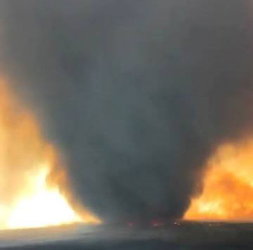
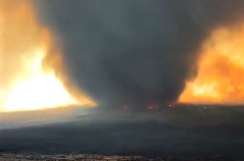
Huge Firenado in Oregon as wildfire onslaught continues

“Pretty wild to see. We’ve all seen fire whirls before, but nothing close to this size.” – Phil Sitz, USWFS

A massive “firenado” is filmed n southeast Oregon July 31, as wildfires sweeping across the pacific northwest burnt almost two million acres of land.

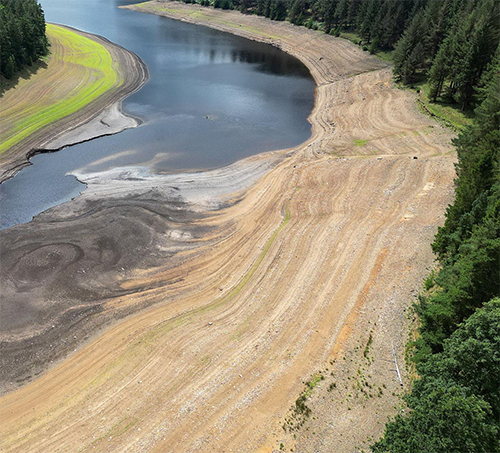
England and Wales recorded their driest July since national records began, with only about one-third of normal rainfall across the UK and far less than that in southern England.

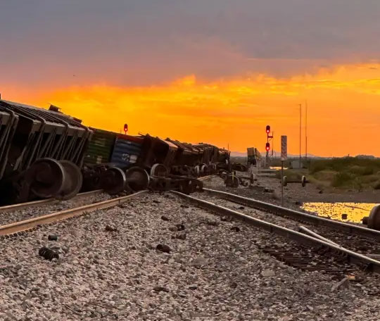
High winds and sand storm derails ~50 car New Mexico freight train

Strong winds from a dust storm are the likely cause of a surprising derailment in Hidalgo County,  The train carried nearly 50 cars and 

Train derailed by high winds

Severe UK drought

BRITAIN-FIRES-MOOR

Drought now 'nationally significant', affecting food supply | The Grocer

Severe drought crisis in UK is severely impacting agriculture

The United Kingdom is experiencing one of its most severe droughts in modern records. The crisis has been driven by an exceptionally dry spring and summer, repeated heatwaves, and very high evaporation rates. Drought was declared across roughly half of England. Authorities say the drought is historically alarming for its combination is intensity and extent. .

The drought has also produced an exceptionally active wildfire season.

The Environment Agency has expanded official drought declarations to include East Anglia, the Thames basin, the West Midlands, Wessex, Devon and Cornwall, and several other regions.

Serious threats to agriculture 

Reuters reports that Britain is heading toward its worst cereal harvest since records began, with irrigation resources running dry. Estimated crop losses could reach millions of tons, costing farmers hundreds of millions of pounds.

UK water restrictions

Water companies have introduced widespread conservation measures.

  • More than 23 million people are now subject to hosepipe bans across England.
  • Additional restrictions are taking effect across southwest England, including Devon and Cornwall.
  • Residents are prohibited from using hosepipes for watering gardens, washing vehicles, and filling pools, with exemptions for certain vulnerable groups.

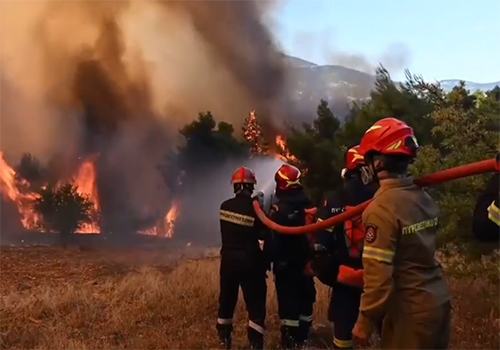
Wildfires threaten Athens

Athens area has lost almost half of its forest to fires

About 42% of the forests that until just ten years ago covered the Attica region, have been destroyed by fire since then, data released Tuesday showed.

More than 51,200 hectares have been lost out of a total 123,000 – some 42%. Ιn its first assessment, WWF Greece said wildfires have forced more than 10,000 residents and visitors from their homes, with burned land expected to top 20,000 hectares,

Satellite images show more than 18,000 hectares scorched since late July in major fires on Crete, Paros, southern Viotia and western Attica.

.

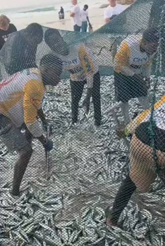
Heating ocean disrupting South Africa marine life and mass fish die offs foul beaches

Major mortality events for sardines and other fish are occurring on the western coastline of South Africa.  The die-off involves multiple species, though sardine remains the most frequently reported. Observations indicate the event spans a significant range, from immediate inshore waters to approximately 50 miles offshore.

While the cause of thousands of dead sardines washing ashore in the Western Cape has not yet been confirmed, experts say climate change is disrupting marine food chains and fish migration patterns.

South Africa’s warming oceans are placing growing pressure on marine life while also threatening the livelihoods of fishing communities along the country’s coastline.


Sardine die-off south africa


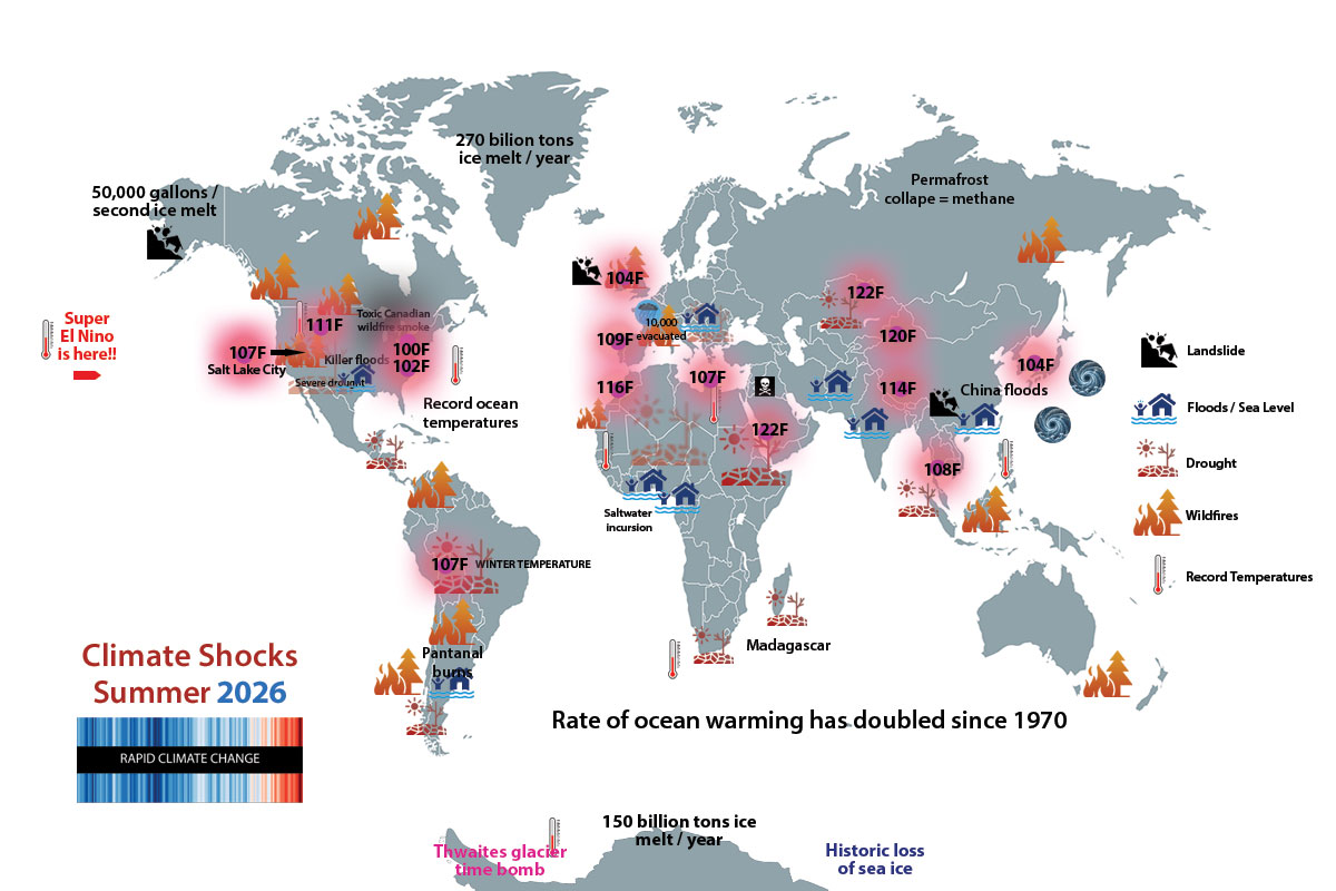
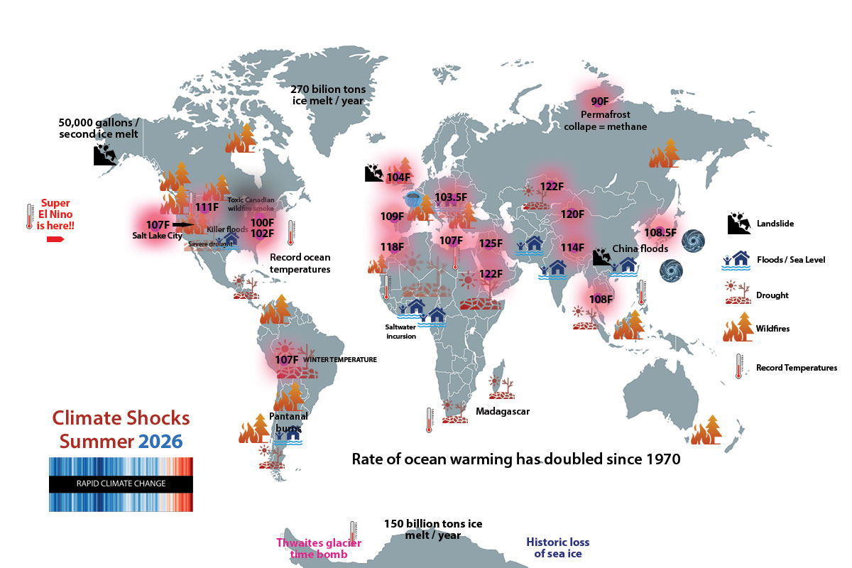
Global Map of Summer Climate Disasters

GLOBAL WARMING WHIPLASH: HEATWAVE | DROUGHT | FLOODS

Update here.

Hottest Day of All Time in South Korea As Temperature Hits 42.5°C


Yangsan, South Korea, recorded a temperature of 108.5°F August 2, 2026. It was the highest temperature recorded in the country on any date since modern weather observation began in 1904.  This was the fifth consecutive day of record heat.  

The city’s latitude is similar to San Fransisco.

“Extreme heat killed two elderly men in South Korea over the weekend, taking the death toll from the ongoing heatwave to at least 16.

Events

“Bordeaux, France, has now recorded more days above 104°F in 2026 alone than during the entire 105-year period from 1920 to 2025.

New all time temperature record in Morocco:  118.5°F.

 New all time temperature record in Liechtenstein: 101.3°F at Balzers.

No Water in Danube to cool Nukes, Rhine at record low

Shipping on Europe’s key rivers has been severely curtailed as water levels reach new lows. Nuclear plants have been shut down in Hungary and the Viking Alur cruise ship ran aground in the Rhine.

Firenado Oregon

Huge Firenado in Oregon as wildfire onslaught continues

“Pretty wild to see. We’ve all seen fire whirls before, but nothing close to this size.” – Phil Sitz, USWFS

A massive “firenado” is filmed n southeast Oregon July 31, as wildfires sweeping across the pacific northwest burnt almost two million acres of land.

Spokane area evacuations as Oregon sets new wildfire records

Dozens of large fires in Oregon have destroyed almost 2 million acres in 2026, surpassing the previous record of 1.93 million acres in the 2024. There was an emergency evacuation of over 300,000 on Aug. 4.

Bordeaux Wildfires

France fire aftermatch

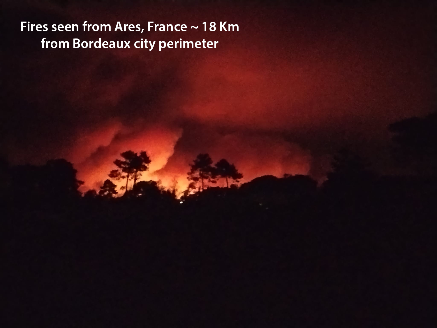
Fires approached 10 Miles of Bordeaux 

The Bordeaux region is under threat from one of the most severe wildfire emergencies in modern French history. The largest fire is burning in the Gironde department, primarily in the Landes pine forest west and southwest of the city. 

The main wildfire has burned about 42,000 hectares (104,000 acres) of forest. Around 220,000 people have been evacuated from communities, campgrounds, and tourist sites. More than 2,500 firefighters, aided by aircraft and international assistance, continue working to prevent the fire from spreading toward populated areas.


Climate factors:

  • Prolonged drought and exceptionally dry forests have combined with an onslaught of heatwaves this summer. Unusually strong winds are contributing to the unprecedented situation. 

France’s First “Fire Cloud” (pyrocumulonimbus) developed near Bordeaux.

A pyrocumulonimbus is a cloud that forms above a large wildfire ​when intense heat drives smoke, ash and water vapor high into ⁠the atmosphere. A rare but increasingly common phenomenon, fire clouds are so intense that they at able to generate their own weather. They are including strong winds and lightning that can ignite additional fires.


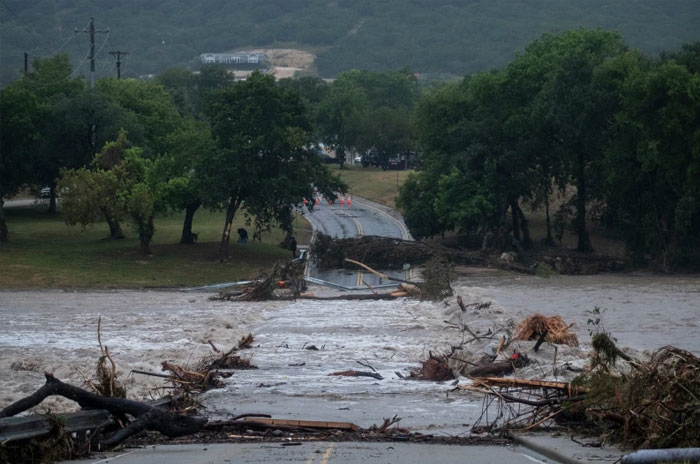
Texas flash floods
Flash floods 2026 hit south central Texas region where dozens of young campers died last year

Many survivors in Kerr County still await aid from last year’s disaster

A year into recovery efforts in west Kerr County, many families are still waiting for permanent housing, rent help and access to resources, according to Hill Country organizations working with survivors.

The Community Foundation of the Texas Hill Country told Kerr County commissioners on Monday that many of the survivors it is working with still need permanent homes.

Only 138 of 641 families have had their cases closed, the foundation said. The organization has 32 case managers working to connect families with assistance.

Welcome to Greg Abbot’s Texas.

Welcome to Donald Trump’s America.

Kerr County floods from 202

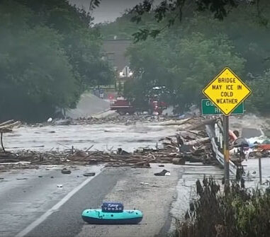
Kerr County & Central Texas hammered by more  killer floods


Two people have died in fast moving flash floods in the same area of Texas still recovering from the deaths of two dozen campers last year. The floods on the Guadalupe River forced hundreds of rescues in western Kerr County,. Rescuers saved more than 200 people, including stranded drivers and people trapped in homes.. More rain is expected.

Aid from the state and federal government has been predictably slow in Kerr County. If you recall Department of Homeland Security approval requirements for FEMA Urban Search and Rescue deployments required personal approval from now deposed and shamed Homeland Security Secretary Kristi Noem.. Some search-and-rescue resources were not authorized until more than 72 hours after the July 4, 2025 flooding began.

Many survivors continue to  experience lengthy delays or denials in receiving FEMA assistance, and this became a significant point of criticism during the months following the disaster.

<

Global Map of Warming Events Summer 2026

Summer 2026 Global Climate Events

“

Floods Sweep Russia’s Urals After 40-Year Rainfall Record Falls


Rainfall in the Sverdlovsk region has continued almost without interruption since the beginning of June.

By the end of the month, precipitation levels had surpassed the previous record established in 1986.

Bulgaria floods

Hail, hurricane winds in Bulgaria

Recovery efforts continue across Bulgaria after powerful storms swept through large the country July 22, bringing torrential rain, hurricane-force winds, intense lightning, and large hail. Cleanup operations remain underway as authorities deal with widespread damage to infrastructure, roads, and public spaces.

Chile Killer floods

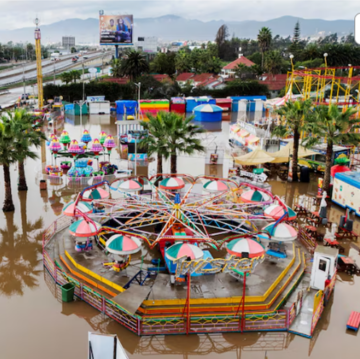
El Niño driven Chilean floods 

Weeklong rainstorms blamed on El Nino that have battered Chile have killed at least 10 people. Another 100,000 have been cut off from services as authorities declared a state of emergency. Thousands of homes have been destroyed. 

Since last week, rain has lashed the typically arid northern regions of Coquimbo and Atacama, where such intense levels of precipitation are highly unusual.

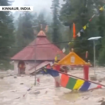
Killer India floods in Himalayas

India’s Himalayan states lashed

Heavy monsoon rain is battering India’s Himalayan states. Himachal Pradesh is under an IMD warning for heavy to very heavy rainfall until July 20, with landslide risks high in Chamba, Kangra, Shimla and Mandi. Meanwhile, Arunachal Pradesh’s crisis is deepening — fresh floods and landslides hit East Siang and Kamle districts, affecting 25 villages in just 24 hours.

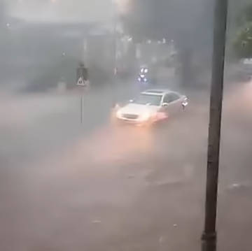
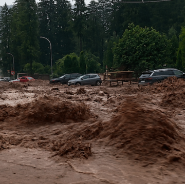
Flash Floods in Romania Sweep Away Cars

Cars swept away in Romania

A powerful flash flood swept through the mountain town of Bușteni July 19, carrying cars, rocks, and debris through the streets and blocking traffic on the busy DN1 national road. Emergency crews rescued several people trapped by the floodwaters, while dozens of homes were inundated

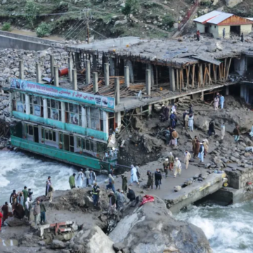
20 dead in Afghan floods

20 Dead in Afghan Floods

July’s floods in Afghanistan are among the country’s deadliest natural disasters of the year, striking after months of repeated flooding had already weakened communities. The worst damage occurred in the mountainous eastern province of Nuristan, where intense monsoon-related rainfall triggered catastrophic flash floods on July 20–21, 2026.

Shanghai floods and heatwave

Shanghai climate whiplash

Record rains followed record heat (104°F)
as Shanghai roads flooded after thunderstorms brought torrential rain to the city on mid-July. More than 8 in. of rain of rain fell within five hours in Yangpu district, inundating underground supermarkets and malls. Local weather authorities expect heavy rain to continue in the coming days.